All over the world, the word rainforest is used rather loosely to denote a type of forest with lots of greenery and rain, right? Well, here I’d like to get into the specifics of the term, rainforest, and define it. I think we should all have a better understanding of this much used term.
True rainforest as a matter of fact, only exists in certain parts of the world. It has to mean lots of rain with no seasonality at all. Generally, this has come to be accepted as areas with rainfall between 1500-2000 mm per month, hot and humid all year round, and a stratified forest where there is a emergent, canopy, undergrowth, and ground layer. The forest also has to be evergreen in perpetuity. So if a “rainforest” is missing one or more of these elements, it cannot really be called a rainforest, but then again, we have other terms for these types of forest, like monsoonal forest, semi-evergreen rainforest and temperate rainforest, among others.
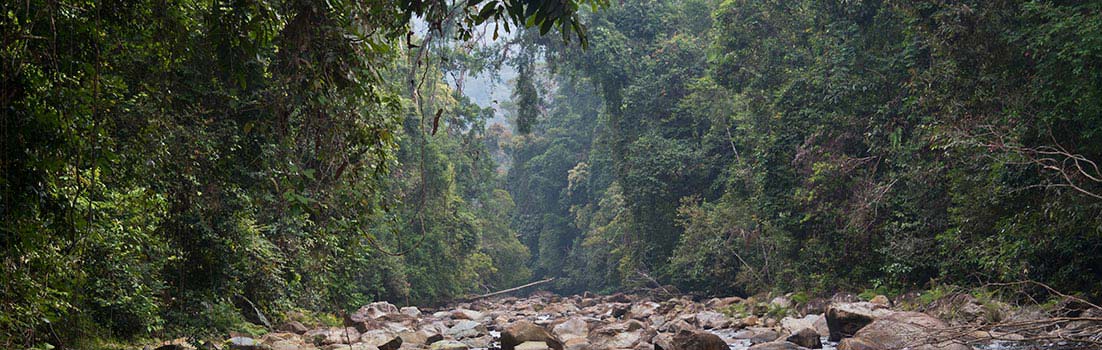
At least as far as I know, here in Malaysia, the vast majority of forest that used to cover this country is called lowland evergreen rainforest, with rainfall all year round, tall trees, having a stratified layer, and no distinct seasonality, save for a few small regions mainly in the north, near the Thai border.
In the Amazon, large tracts are actually not true evergreen rainforest, contrary to popular opinion, but have a distinct seasonality (a massive drought ravaged the Amazon a few years ago). Also, much of the basin around the river is a rather short stature forest (upper canopy 20-27 m high) that borders on freshwater swamp forest, seasonally inundated by the Amazon. But from the air, aerial photos of the Amazon often show a vast carpet of green, which many people understandably call, “rainforest.” That said, there are also many areas, like along the Andes foothills and in Central America, where true evergreen rainforest exists.
The same rationale goes for vast tracts of the Congo “rainforest,” that is actually more akin to semi-evergreen rainforest at best. There are many open areas in the Congo forest that have tall grass and bushes, while the more dense areas are populated by many types of trees that shed their leaves on a periodic basis. Comparable areas can be seen in the “rainforests” of Indochina and India.
In Malaysia however, the forests are very uniform, and the rainfall does not really vary much from year to year. With the exception of El Nino induced droughts and also heavier rain during the end months of a year, most forest areas in Malaysia can be classified as “true evergreen rainforest.” The canopy is unbroken, and there are no open areas populated with bushes; although some trees are seasonal, most of the trees are true evergreen trees.
Perhaps this is the reason why you can find very tall trees here? On the island of Borneo, tall trees 60-70 m tall are very common, especially in the northern half of Borneo. Some trees even exceed 80 m high (but widespread logging decimated almost all of them). Ideal conditions permit the rainforest to develop to its full glory, complete with all the strata you would normally associate with a “true rainforest.” Biodiversity is also extremely high, resulting in the most species rich rainforest anywhere on earth (on most biodiversity/area ratios, Malaysia has the highest ratios in the whole world).
But for convenience’s sake, we and most people would probably just call everything – Jungle….

April 22, 2022 at 4:52 am
I suppose this crosses out the montane to midland rainforests of the Western Ghats as true rainforest then, even though rain occurs quite frequently for 8 to 10 months in the areas of the Southern Western Ghats (8-12°N), with mist being the secondary form of precipitation for these forests during the dry season. along with that when you go further beyond this latitude the dry season increases with the the Central Western Ghats (12-16°N) have a dry season 8 to 6 months while the the Northern Western Ghats (16-20°N) have a dry season of 6 to 4 months
I also have to point that the monthly rain fall in Borneo sits at 200mm and the annual rainfall is what is at 1500 – 2000mm while ghats register up to 10,000mm sometimes with 3000mm to 5000mm being the norm during the rainy season. along with stratification does occur with a well developed canopy, undergrowth, understory and forest floor
though I don’t think using the term semi – evergreen rainforest is accurate as the montane” rainforests found in the ghats possess no deciduous elements and most of the time are purely evergreen with only degraded areas having deciduous elements artificially introduced into it. the areas in the ghat’s experience a very hot humid and tropical climate with 80% humidity throughout the year with it soaring to 100% during the wet season.
I think a more accurate name would be non – equatorial semi – seasonal rainforests, As unlike true rainforests found along the equator these are located away from it and semi seasonal due to short and quite negligible dry season. along with that the rainforest in the ghats have trees with a height of 40 to 45 in elevation from 700 msl to 1700 msl if my memory is correct with the tree height decreasing with higher altitudes. though I suppose true stretching it you can consider the seasonal rainforests as those found in the Central Western Ghats as semi – seasonal rainforests while those found in the Northern Western Ghats as true seasonal rainforests
I hope you reach out to me so we can have a more well thought out discussion about this.
April 22, 2022 at 6:07 am
On my last paragraph I mentioned a more accurate term for the wet forests of the ghats being non – equatorial semi – seasonal rainforests, now that I think about it a more accurate term would be non – equatorial monsoonal rainforests, as the main source of moisture for these forests are both the northeast and southwest monsoons. with the ground water in the water table being the second most prominent form of water, convectional rainfall being the third most prominent and mist and fog being the least prominent.
April 23, 2022 at 8:09 pm
@Aneetha
I’m going with the definition set by T.C. Whitmore of tropical evergreen rainforest, from his classic work, “An Introduction to Tropical Rain Forests”.
May 13, 2022 at 12:25 pm
Have you taken a look at the tropical “rainforests” of the western ghats?, what are your thoughts on them in terms of both what they are and how biodiverse they are?
May 13, 2022 at 6:58 pm
@ Aneetha Salim
From photos of the Nilgiri Biosphere Reserve, it looks very different from the forests in Malaysia, for sure. There are also barren hillslopes with no vegetation on them, but moister valleys contain a “standard” rainforest. In Malaysia, there are practically no (naturally) barren hillslopes unless the soil layer is too thin. Without human disturbance, the forest here would blanket everything from coast to coast.
May 15, 2022 at 12:22 pm
The barren hillslopes you’ve seen are probably a type of endemic forest type known as the shola – grassland complex, a type of cloud forest found only above 1500 msl in more temperate altitudes, they’re considered part of the rainforests but are more akin to the Himalayan flora rather than the more tropical flora which is found in the lower altitude areas from 200 msl to 1500 msl, a more accurate representation of the wet forests in the ghats would be silent valley national park, periyar national park ,shendurney national park and amarambalam reserved forest.
May 15, 2022 at 2:42 pm
@Aneetha Salim
It is clear from numerous images (including from Wikipedia), that the Nilgiri Biosphere Reserve is not cloaked entirely in tall rainforest, and there are large areas even in the lowlands, where a kind of semi-open forest/bushland, or even slightly wooded grassland/savannah is the prevailing habitat. This is very unlike Malaysia where there are no open naturally occurring grasslands. As I said before, the rainforests here would cloak the country from coast to coast if there were no humans.
May 15, 2022 at 4:28 pm
That’s why I mentioned the other national parks, as they are more of a accurate representation of the wet forests of the ghats, Here unlike in Malaysia the forests types are dependent on altitude with it going from southern tropical scrub forest < southern tropical mixed moist deciduous < wet coast tropical wet semi evergreen forest < southern tropical wet evergreen forest < southern subtropical broadleaf hill forest < southern montane wet temperate forest interspersed with southern subtropical wet savannah and southern subtropical wet grassland.
Unlike Malaysia which has an AF climate on the koppen Geiger scale, the climate here is AM on the same scale more akin to the climate of Java than Malaysia, this results in a more seasonal climate. Most of the Nilgiri plateau is covered by sholas with the actual windward areas being the ones of interest to us both, That's why a better representation would be periyar tiger reserve or silent valley. Along with the forests aren't the lowland rainforests found in SE Asia they're montane in nature so outward appearance is quite different.
May 15, 2022 at 4:37 pm
@Aneetha Salim
So what was your point again? India has a seasonal rainforest, therefore it cannot be called an evergreen rainforest. Even looking at the world map, you will see the latitude of the Ghats is further from the equator compared to other countries or regions that are actually at the equator (or closer).
May 17, 2022 at 7:12 am
Now that I think about it the ghats aren’t true rainforests as their is a short but present dry season, so yeah I suppose calling the rainforests of the ghats monsoonal rainforests is correct. Do you think the same classification applies to the wet tropics of australia?
May 17, 2022 at 9:51 am
@ Aneetha Salim
I guess it is probably right as well to regard the Australian rainforests as monsoonal or seasonal rainforest. Because looking at their location and comparing with the latitude on the world map, we can see they are some distance away from the equator. Even in Malaysia, I can tell you the areas in north Malaysia, like the state of Perlis and Langkawi island, and also the far northern regions of Sabah, like in Kudat (you can look these places up in Google), they contain seasonal rainforest too and there is a marked dry season there. The difference is subtle, but the species of trees are markedly different than from areas lower south.
May 17, 2022 at 11:47 am
what are your thoughts on the present biodiversity of the ghats?
May 17, 2022 at 4:30 pm
@Aneetha Salim
The Ghats are undoubtedly rich in flora and fauna species. Since there are so many different types of habitats there.
May 18, 2022 at 3:47 am
do you have any theories on why there is a vertical transition from deciduous elements to evergreen elements with increasing altitude?
May 18, 2022 at 4:53 am
@Aneetha Salim
I suppose it is more moist at high altitudes, especially at the cloud zone. That’s why you get mossy forests on high tropical mountains.
May 18, 2022 at 7:55 am
So in essence the monsoonal rainforests found in the ghats are in essence just tropical montane cloud forest, rather than a proper equatorial lowland rainforest?, also I think you should take a look at Madagascar’s rainforests, the area even though away from the equator has an actual tropical rainforest climate.
May 19, 2022 at 4:21 pm
@Aneetha Salim
Sorry, I cannot speak for other places as I’ve not been there myself. Certain places like valleys and islands may have distinctive micro-climates. But there are many arid places in Madagascar too, as inferred from their baobab trees that develop fat trunks to store water.
May 19, 2022 at 6:17 pm
@Aneetha Salim
Non-equatorial coastal tropical rainforests are often affected by cyclones, which may be one of the reasons why the Western Ghats forests are less developed than equatorial regions and have a lot of montane grasslands. Dehing Patkai in the Assam Valley is a good example for a more typical evergreen rainforest. Due to the influence of the southern branch trough, there are abundant spring rains and short dry periods, and Shorea assamica constitutes a tall emergent layer.
May 20, 2022 at 6:10 am
@Hang lee
I wouldn’t say that the rainforests of the ghats aren’t developed, As like all tropical rainforests, the forests here are well stratified and have defined layers to it, with some emergent trees reaching upto 60 to 70m in height, A more accurate term would be degraded heavily degraded, The once lush coastal rainforests and occasional semi evergreen forests covered the entire windward side of these mountainous though they are now secluded to the mountainous eastern half of the country, records suggest that there once existed a contiguous band of tropical rainforest on the coast.
But as of now years of colonial logging and deforestation for timber extraction and production, plantation farming of a variety of crops and development projects have left these forests as a prior shell of their once expansive past, from records of evergreen forests stretching for miles on end to having less than 17,000 sq kms of the once expansive forest cover which was found on an area of 180,000 sq km’s, The current state of these forests is left in the form of fragmented habitat mosaics and national parks. This reduction in forest cover has also weakened the monsoon and resulted n more peril for these forests.
The Dehing Patkai Landscape is a more typical evergreen rainforest due to it’s less montane nature though due to being situated in the Himalayas the area still ranges from 800 to 900 msl so not that low lying in nature. I also have to ask what is the minimum wet season needed for an area to be considered a rainforest?
May 20, 2022 at 6:15 am
@JungleBoy
Madagascar is interesting in that area experiences trade wind based year-round do due it’s position in the indian ocean, the central mountain range acts as a barrier resulting in plentiful precipitation on the eastern side and a rain shadow causing it’s semi arid climate akin to the effect the ghats have on the indian peninsula.
May 20, 2022 at 6:16 am
@JungleBoy
Can you give a short explainer on what are Kerangas? are they a type of rainforest?
May 20, 2022 at 6:43 am
@Aneetha Salim
I highly doubt there are trees 60-70m in height in the Ghats. Please look up images of the Big Lonely Doug fir tree online to get an idea of the stature of a 70m tall tree. There are images of it with people next to it. As for Kerangas forest, it is mostly restricted to areas in Borneo where the forest is of lower stature, due to the soil being poorer in nutrients and is a stunted version of a classical lowland tropical rainforest.
May 20, 2022 at 6:54 am
@Jungle Valley
I must have misremembered then though I do remember a few papers regarding silent valley stating that the canopy height was about 35 to 40 meters, With the emergent layer reaching about 60 or so meters, I may be remembering it wrong though.
May 20, 2022 at 6:56 am
@JungleBoy
I assume this forest type has an overall high degree of endemism?
May 20, 2022 at 10:58 am
@Aneetha Salim
Yes, the Kerangas forest has its own unique species of flora and fauna.
May 20, 2022 at 3:56 pm
@Aneetha Salim
According to the Köppen climate classification adopted by Wikipedia, the tropical rainforest climate should not have a dry season for even one month (at least 60mm of precipitation per month), in fact, the rainforest does not need such harsh conditions. Sites that meet the criteria for a tropical monsoon climate under the Köppen climate classification usually develop evergreen rainforests, because total precipitation is sufficient or the dry season is less pronounced, and the water retained in plants and in the soil is enough to supply the short dry season. Some semi-evergreen rainforests also exist in the tropical wet and dry climate zone of the Köppen climate classification, possibly due to the humid environment caused by topography.
May 20, 2022 at 4:15 pm
@JungleBoy
In terms of precipitation, there is no dry season on the east coast of the Philippines, but the rainforest emergent layer is obviously not as developed as Borneo, because the former is too severely affected by typhoons. The northernmost tip of Sabah and the border areas of Malaya and Thailand may also have this influence.
May 21, 2022 at 3:16 am
@Hang Lee
The western coast of India experiences a tropical monsoon climate, Up till the 16th parallel north the dry season is limited to 1 to 4 months with it decreasing further south until the dry season is limed 1 or 2 months, This area is also one of the more diverse regions of indian subcontinent with the presence of periyar national park, which has about 1900 species of plants in it’s core area of 300 sq km, The region between 8°N and 16°N I suppose can be touted as a proper rainforest, as both the overall high altitude, combined with water contained in the soils, which are sufficient enough to feed the perennial rivers throughout peninsular india, I’m more so asking about what is the minimum wet season needed or an area to be a considered rainforest?
Yeah I don’t think a lot of rainforests come close to Borneo’s in terms of both development and biodiversity, except maybe some parts of the amazon, the emergent layer in the ghats are just exists in the form of a few trees poking out the canopy due to it being located in higher altitudes the development of a proper canopy is quite hard, Though typhoons and all aren’t actually that common here, they mainly occur on the eastern coast.
May 21, 2022 at 4:44 pm
@Aneetha Salim
I don’t think you need to struggle “with what is the minimum wet season needed”, Wikipedia thinks the original vegetation in the Malabar Coast moist forests was tropical evergreen rainforest (https://en.m.wikipedia.org/wiki/Malabar_Coast_moist_forests) and UNESCO thinks the forests of the Western Ghats include some of the best representatives of non-equatorial tropical evergreen forests anywhere (https://whc.unesco.org/en/list/1342).
May 22, 2022 at 6:32 pm
@Aneetha Salim
In addition to the length of the dry season, there are many other influencing factors such as total precipitation, soil, topography, etc. As for “an area to be a considered rainforest”, it’s mainly based on the plant composition of the community, the rainforest is more complex and diverse than the monsoon forest.
May 23, 2022 at 3:26 am
Can you go a little more in-depth by what you mean by plant composition?
May 23, 2022 at 2:46 pm
@Aneetha Salim
For example, In Assam, Dipterocarpus macrocarpus and Shorea assamica dominate the rainforest, many features thought to be tropical rainforests are evident in this type of forest, and Shorea robusta is the symbol of the monsoon forest
May 24, 2022 at 3:56 am
Oh, There is also a dominance of dipterocarps in the ghats some 13 species, though most commonly you’ll most commonly find an association involving cullenia, I know of a paper regarding this http://216.10.241.130/pdf/open/PDF_45_2/45210.pdf .
May 25, 2022 at 3:57 am
@Aneetha Salim
The paper mentions that wet evergreen forests generally occur under high rainfall (>2000 mm) and low number of dry months (<4 months) and extends from the extreme south of India up to Ratnagiri. But Ratnagiri and Goa to the south have a dry season of six to seven months, so I'm guessing maybe the dry season at the foothills of the western slopes is shorter than in the seaside cities.
Mumbai in the north has a tropical wet and dry monsoon climate, too dry for evergreen forests, and Kochi in the south has a tropical monsoon climate, suitable for evergreen rainforest growth.
May 25, 2022 at 12:43 pm
Yeah wet evergreen forests typically occur in areas where rainfall is high and the dry season is short, This means that most of the time proper wet evergreen forests are only found from the central western ghats to the southernmost parts of india, A good example would be agumbe which has a dry season of 4 months or so and is one of the more well know well known forests in india, Other area with wet evergreen forests beyond 16 degrees north are mostly area’s with high annual rainfall with evergreen vegetation present due to the percolated water within the soil Look at the sacred grove of Ajeevalli as an example https://roundglasssustain.com/habitats/sacred-grove-ajeevali or Amboli https://roundglasssustain.com/photo-stories/amboli-western-ghats,
Yeah the dry season in higher altitudes is much shorter as they get both rain from the northeast and southwest monsoon and experience the most rain as they directly receive the rains from the orographic precipitation, so a place like periyar receives much higher rainfall than let’s say Alappuzha,
I have two other interesting papers that regard this
http://wgbis.ces.iisc.ac.in/energy/lake2012/fullpaper/sumesh_fullpaper.pdf
https://www.researchgate.net/publication/40686981_Evidence_of_Late_Palaeocene-Early_Eocene_equatorial_rain_forest_refugia_in_southern_Western_Ghats_India
May 26, 2022 at 2:35 am
@Aneetha Salim
It is interesting that they divided the Western Ghats into three sections, 8-12ºN may be closer to the equatorial forest, 12-16ºN may be the most representative rainforest type in this region, and 16 degrees is roughly the dividing line between tropical monsoon climate and tropical wet and dry climate, north of that is mainly monsoon forest, and small pieces of rainforest exist with the help of special terrain.
I am interested in the canopy of the rainforest, do you have any photos of it?
May 27, 2022 at 3:08 am
Yeah, The division of the western ghats is also from a biological standpoint as total species richness, density and endemism increases drastically as you go south, A good way to put it would be that out of the more than 5800 angiosperm taxa found here more than 80 percent are found in the latitudes from from 8 -12°N,
Yeah I Have some photos
Northern Western Ghats
https://bit.ly/3lR9ON2
https://bit.ly/3t168fQ
These are all during or directly after the monsoon
Central Western Ghats
https://bit.ly/3wPFqZM
https://bit.ly/3z1QODr
https://bit.ly/3LQsIOD
These are a mixture of both pre and post monsoon photos
Southern Western Ghats
https://bit.ly/3Gn0Xwe
https://bit.ly/3lP6hiA
May 27, 2022 at 3:12 am
There’s also these photos from the southern western ghats
https://bit.ly/3NCAw7X
https://bit.ly/3sVxHan
May 28, 2022 at 2:42 am
Hang can you give me your email address, I think it would be better to discuss this through email as the discussion now seems a bit too long winded to be done via a blog.
May 28, 2022 at 3:08 pm
wow, thank you Aneetha, very beautiful photos, western ghats is really unique and diverse.
May 28, 2022 at 3:34 pm
You should watch wild Karnataka the documentary has some good cinematic shots of the ghats.
July 22, 2024 at 7:47 pm
@Paul Docherty
I don’t think there has ever been any studies at Gunung Pulai for those things you mention.