Background
Endau Rompin National Park is an expanse of mainly primary tropical rainforest in the south of Peninsular Malaysia, named after two major rivers, the Endau and Rompin Rivers which derive their watershed from here, and occupying a total area of 87,000 ha. The park straddles the states of Pahang and Johor, with the Johor side being gazetted as a national park (49,000 ha), while the Pahang side (38,000 ha) is still a state park (if not mistaken) and managed separately by the Pahang state authorities.
This “dual” status of Endau Rompin may be the reason why Endau Rompin is listed as a state park in Pahang, while being listed in Johor as a national park. For those wondering, the difference between a state park and a national park is that a state park’s status can be overturned by the state assembly, while a national park’s status can only be overturned at the federal/national government level. Obviously, a national park affords better protection.

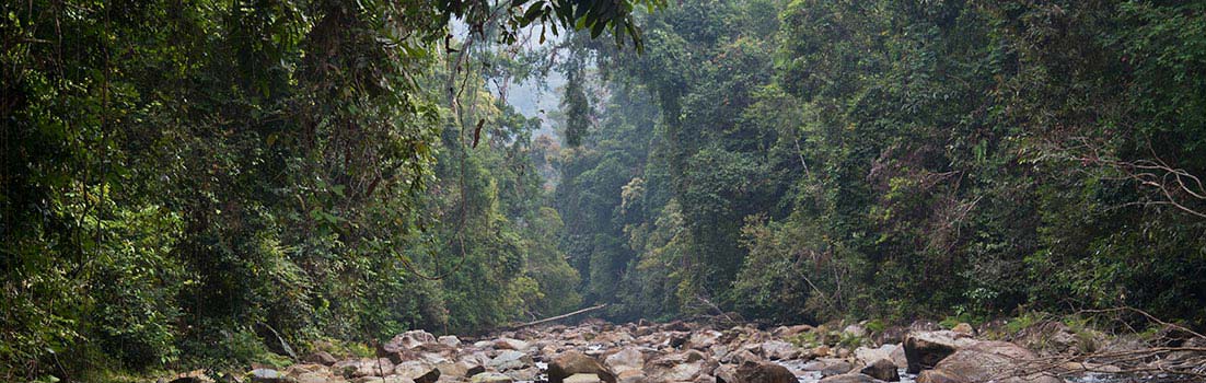
Endau Rompin protects a range of habitats that are in grave danger of disappearing. Here, the undisturbed mixed dipterocarp forest in the heart of Endau Rompin Selai.
Manmade edicts aside, what makes the Endau Rompin forest so special and worthy of conservation is its pristine tropical rainforests spanning a wide range of forest types, and its varied and rugged landscapes which are unique only to this area. The unique landform features of Endau Rompin have given rise to numerous waterfalls ranging from beautiful little trickles all the way to impressive thunderous cascades pouring down over rocky cliffs. The rivers are just as fascinating, from boulder strewn rapids, to slow meandering rifts.
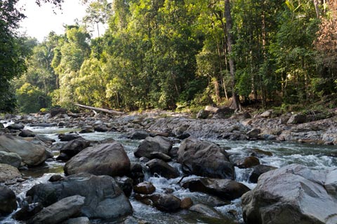
Boulders along the Selai River. These boulders are mainly volcanic in origin.
Endau Rompin is unique from a geological standpoint. Its mountains are flattish topped sandstone plateaux massifs and not part of any major mountain chain in Peninsular Malaysia. As such, these hills bear a type of heath (kerangas) forest which is otherwise uncommon elsewhere in Peninsular Malaysia, and contain some uncommon or endemic species like the beautiful Livistona endauensis, a fan palm once thought to only occur in Endau Rompin (but has since been found elsewhere).
The Selai River has its upper catchment in the south-western portion of Endau Rompin. This is a hilly area with many waterfalls.
Endau Rompin has long been believed to be the last refuge for the highly endangered Sumatran rhinoceros, and it is for this reason that a well publicized expedition to uncover its biological treasures was carried out in 1985-1986 by the Malaysian Nature Society (MNS). Subsequent expeditions have since confirmed Endau Rompin to be a treasure trove of biodiversity and new species/findings are uncovered each time scientists make a sustained effort to peer into its green depths.
The Johor side of the park is managed by Johor National Parks Corporation, and has two entrances, namely at Selai and Peta. The Pahang side of the park (which really needs more visitors) has its entry at Selendang, near Kuala Rompin. Presently, the nearest and easiest entry into Endau Rompin is at Selai, a relatively new entry point developed since 2003, while the traditional entrance (developed since the 1985 MNS expedition) is the Kampung (Village) Peta entrance, accessible from Kahang town in Johor. Both Johor entry points have a well developed tourist infrastructure already in place for the adventurous ecotourist.
Getting there
Recently, I paid a visit to Endau Rompin Selai. To get to Selai, the easiest way is to travel along the North-South Expressway, with your destination as Yong Peng, a town in Johor. Turn into Yong Peng from the highway. From there, the next town is Chaah, and after that you will arrive at Bekok town. Bekok is where the management office of the Endau Rompin Selai is sited, and you will need to register yourself here. From here, 4WD vehicles (whether personal or chartered) will take you past a Ranger Post near Sungai Kemidak, and onwards to the camping site at Lubuk Merekek and main visitor complex at Lubuk Tapah, some 6 km away. It is NOT recommended to drive from Bekok to Selai with a sedan car; there is a risk the rough and only partially sealed road will damage your car.
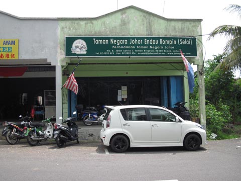
The Endau Rompin Selai management office at Bekok. All visitors must register here before entering the park.
For those taking the railway, it is even easier; just buy a ticket to Bekok, which is one of the stops on the KTM South Line. Upon arrival, you do not have to travel far; the railway station at Bekok is located near to the park office.

The rough road to the park passes the Labis Forest Reserve, settlements, orchards, rubber, and oil palm estates. Here, a jungle hut built over some cleared land, seen on the way in. This could be a scene from Malaya many decades ago, but today most of the “dense jungle” is already long gone.

The reception building at the main visitor complex, Selai Base Camp. There is a new telecommunications tower in the background, built a few months ago. This permits 2G phone coverage. The facilities here are simple and adequate, but can only support a limited number of tourists at any given time.

Looking downstream from Lubuk Tapah, at Base Camp. The Selai bends around a pseudo island called “Orchid Island” (Pulau Orkid), on the right. The Arboretum is connected to it as well.
The main visitor complex adjacent to Lubuk Tapah is equipped with a cafeteria, a small multi-purpose hall, dorms and chalets, and further down by the riverside, there are jungle huts for rent as well. All in all, the accommodation is adequate but not luxurious, built for the visitor who doesn’t mind to rough it out a bit. The superb location of the visitor complex permits a splendid view of Gunung (Mount) Tiong on most days, as well as the surrounding lowland rainforests, hills, and ridges. There is also an aboriginal Jakun plot (Orchid Island) where aborigine displays/exhibitions may be held from time to time, as well as an arboretum next to it (many trees are tagged here).

Dawn breaks at Endau Rompin Selai. The strategic location of the Base Camp affords great views all around.
Flora and Fauna
Endau Rompin is a major conservation area in Peninsular Malaysia and the largest national park after Taman Negara (other major conservation areas like Belum or Krau are not national parks). The Selai region of Endau Rompin is definitely more rugged and hilly than the Endau-Jasin area, which means there is little forest on flat ground; all the flatlands outside the park have been logged and turned into oil palm estates, as you would have noticed on the way in.

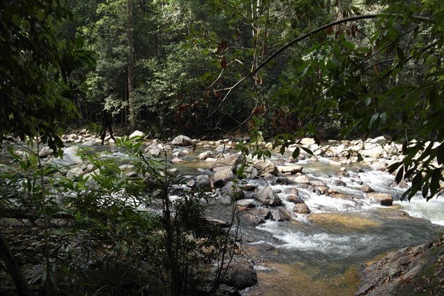
Looking down at the Selai River and forest alongside it, from one of the main trails on the high river bank. The tree fern on the right is most probably Cyathea latebrosa.
The last 2 km stretch of road to Lubuk Merekek and Lubuk Tapah does pass under remnant lowland dipterocarp forest on flat ground, alongside the Selai River. Although this patch of flatland forest may not be totally undisturbed (from past human activities), it is still a very rare type of lowland forest today, only occurring in a few protected areas, when once upon a time they blanketed most of the country. Here, I imagine birding would be excellent, under the crowns of huge rainforest trees interspersed amongst an extremely broken and uneven main canopy layer, and the occasional strangler fig tree here and there.

A big Mersawa (Anisoptera laevis) tree, probably between 1.5 to 2 meters in diameter, found near Lubuk Merekek. There was a much larger Mersawa nearby, perhaps 3 meters in diameter, but it died some years ago. The park office still has photos of this enormous tree. This species is often found near streams or rivers.

Bauhinia kockiana, a rainforest climbing vine which blooms all year round, adding splashes of bright orange to the canopy, when seen from above.
The lowland forest on undulating terrain at Endau Rompin Selai is classified as Keruing-Red Meranti dipterocarp forest, with a typical canopy height of 25-30 meters above the ground, and emergents rising above that at 40-50+ meters tall. Big trees of Dipterocarpus, Shorea, Anisoptera, Koompassia malaccensis, Palaquium, Sindora, etc, can all be found here. Huge examples of Mersawa (Anisoptera laevis) can still be found in the lowland forest alongside the Selai River, in association with numerous big Keruing (Dipterocarpus) trees. Slightly higher up in altitude, the hill dipterocarp forest comes in, with its characteristic Seraya (Shorea curtisii) trees.
So far, the forest types identified at Endau Rompin Selai include:
- Riparian/riverine forest
- Freshwater swamp forest (small patches around the Selai River)
- Heath forest
- Lowland dipterocarp forest
- Hill dipterocarp forest
- Lower montane forest (on Gunung Tiong)
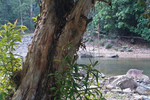
A River Pelawan (Tristaniopsis whiteana) at Lubuk Tapah. Note the charming swing. Pelawan trees shed their bark in scrolls, similar to Eucalyptus, which they are related to.
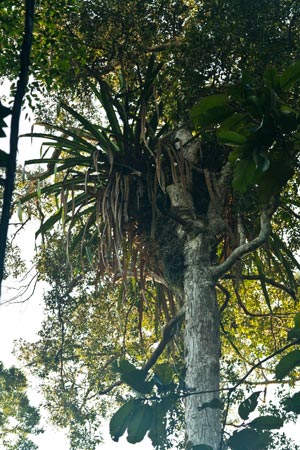
Pandanus epiphyticus is amongst one of the largest epiphytes in the world. Common in Endau Rompin, and one of the distinctive flora features here. It is a species of pandan plant, albeit one that grows in tree tops.
Within these forest formations, many distinctive features have been identified. For example, the riverine forest is lacking a shrub, Phyllanthus watsonii, which is otherwise common at the Endau-Jasin area further east. During my trip, I also did not encounter the rheophytic fern, Dipteris lobbiana, otherwise common in the Endau- Jasin river basins. A major absentee along the waterways is the Neram tree (Dipterocarpus oblongifolius), which here at Endau Rompin is replaced by the River Pelawan tree (Tristaniopsis whiteana). In the lowland/hill dipterocarp forest at Selai, the Kapur (Dryobalanops aromatica) tree appears to be absent, but otherwise grows in abundance further east and north-east in Endau Rompin.
An ornamental begonia, Begonia rajah, has been found at the Selai waterfalls as well. This begonia was first documented in the 19th century from a location in Terengganu (which went unrecorded), and has never been encountered again until the 2002 expedition. Thus, it is considered very rare.

A new species of red durian, that was discovered in 2002, at Selai. The fruits are very small, around 5-6 cm in length. Both flowers and fruits grow from inflorescence at the base of the trunk.
I also encountered a rare flowering and fruiting species of red durian here, which I was told by my guide as being a species new to science, and was only discovered during the 2002 expedition. In general, fruit trees are abundant at Selai, and during my visit, I sighted many specimens of fruiting trees and palms, like Tampoi (Baccaurea) and Nangka/Jackfruit, among others.
The Malaysian Walking Stick Palm, Rhopaloblaste singaporensis, is very common in the Endau Rompin forest on well drained soil. It is so named because when young, its straight stems can be cut and used as walking sticks.
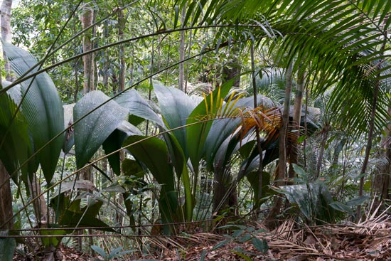
The “Daun Payung”, which means “Umbrella Palm” (Johannesteijsmannia altifrons), is found all over Endau Rompin. J. altifrons is the most common species of this magnificent palm genus.
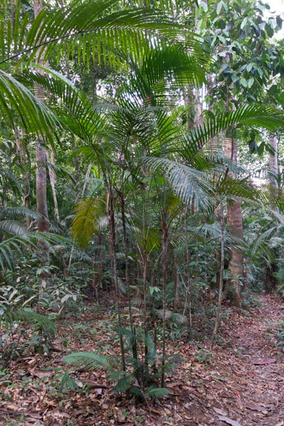
The undergrowth in the lowland forest on the undulating-hilly terrain is littered with palms, most commonly encountered being Nenga macrocarpa, Oncosperma horridum, Eugeisonna tristis, Johannesteijsmannia altifrons, Rhopaloblaste singaporensis, and species of Licuala fan palms. Meanwhile, the forest lining the river banks is a often a huge, messy tangle of climbers and small trees due to the broken canopy, with big trees like Shorea leprosula frequently spotted growing behind riverside trees like Ixora and Saraca spp.

From this pic at Lubuk Tapah, you can make out Tinfoil Barb/Lampam Sungai (Puntius schwanenfeldii) with orange tails and dorsal fins, and Apollo Sharkminnows (Luciosoma setigerum) with horizontal black stripes across their body.
Fish life is abundant at Endau Rompin Selai. I believe every body of water I looked at, even the side pools of streams, contained fishes of some sort. The main Selai river teems with Tinfoil Barb/Lampam Sungai (Puntius schwanenfeldii), Apollo Sharkminnow (Luciosoma setigerum), as well as a variety of Kelah (Tor douronensis) and Sebarau (Hampala macrolepidota). Higher upstream, there are plentiful shoals of Rasbora fishes; some of these are ornamental fishes. Fishing (with permit) is only allowed downstream from Lubuk Merekek.
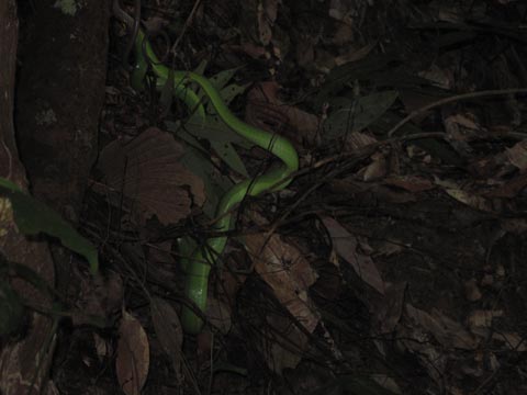
A White Lipped Pit Viper (Cryptelytrops albolabris), which was spotted in the dense undergrowth near a stream. These are poisonous snakes, but their bite is usually not fatal. Most vipers are usually sluggish and mild mannered during the day. Still, it is best to always give them a wide berth.

Elephants are found at Selai, but are infrequent visitors here I was told, being more common at the Jasin-Endau basin. These droppings are rather old.
Endau Rompin still harbors elephants, tigers, deer, tapir, leopards, sun bears, wild boar, etc; its birdlife is also no less impressive. During my stay, there was a male Great Argus pheasant calling prominently throughout the day and night, while gibbon calls came in like clockwork during dawn. I also encountered the couple of Bearded Pigs (Sus Barbatus) which are believed to only occur in Johor and South Pahang in Peninsular Malaysia, having gone extinct in other states. Camera trapping photos confirm the presence of all the main mammal species in Endau Rompin, with the exception of the rhino.
Sadly, latest surveys indicate that the Sumatran rhino is no longer present in the park; the last obtained evidence of their presence being in the 1990s, and it may well have gone extinct in the whole of Peninsular Malaysia since then. The rhino was the main reason for the park’s creation, and Selai was believed to be rhino country – until recently.
Conservation
The continued integrity of the park’s ecosystems/habitats needs to be maintained if Endau Rompin is to continue being a successful conservation story. During my visit, I observed the Selai River was slightly murkier than I expected, especially at Lubuk Merekek, where siltation was a little heavy. From early accounts of visitors and past photos, the Selai River was a lot more clear and beautiful just a decade ago. In Google Earth, you can clearly see heavy logging activity having or currently taking place in the long strip of land that encompasses at least a kilometer wide on the opposite bank of the Selai River, running parallel with the access road, that for some reason was never included within the park’s boundaries. This large strip includes much of the prime lowland forest along the base of Gunung Tiong, now lost forever. The massive deforestation cannot be seen by visitors at the Endau Rompin Selai Base Camp, only from Google Earth, and it is pretty upsetting (but not surprising, of course).
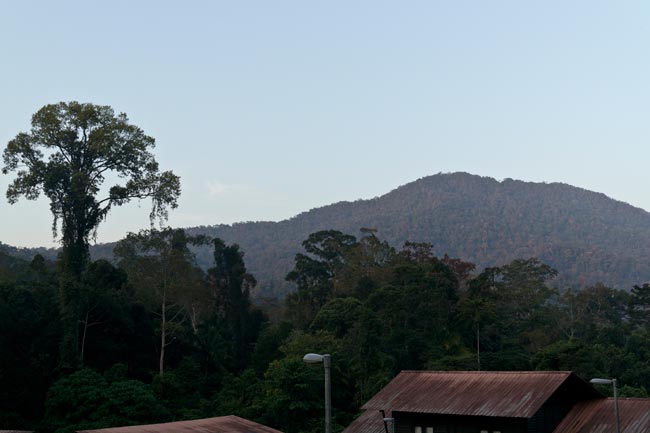
Evening view from the main visitor complex, looking towards Gunung/Mount Tiong (1014 m).
Now here’s the problem. Lax enforcement due to corruption and greed is an inherent problem in this part of the world, and it is a fact that timber firms almost always steal “extra” timber from adjacent forests that are not in their concession, as long as it is nearby and available. It is hard to pinpoint if illegal logging has taken place within Endau Rompin’s borders without any proper current maps, but it is definitely something everyone needs to be aware of, especially for those going there.
The country’s premier national park, Taman Negara, is very likely to be suffering from this problem of illegal logging, especially on the Kelantan side of the park, where there is next to no buffer zone; almost all the forest cover outside the national park’s boundaries in Kelantan was logged/cleared to plant vast oil palm plantations right up to the very border of the park. And recently, further forest clearance further destroyed the environment near Kuala Koh.
A few years ago, there were massive floods at Selai which literally changed the river’s flow and bed, as well as sweeping away at least two bridges (one at Lubuk Tapah, and another at Lubuk Merekek). Could these floods be related to, or worsened due to illegal logging activity within the park’s catchment areas?

Map I created of Endau Rompin and the Selai area, with major waterfalls and Base Camp shown (approximate locations). Note the heavy logging activity on the other bank of the Selai River (not part of the park). Click to see the larger version.
The Waterfalls and Trails
Endau Rompin Selai is best known for its waterfalls (or Takah in the local Jakun language), and my visit entailed hiking to some of the main ones. Although the trail system at Selai is somewhat limited from my point of view as they all head to waterfalls and do not stretch far, most of them are over steep river banks and rugged terrain, so cannot be considered a walk in the park. A certain level of fitness is required, and a guide is compulsory to take along for every trek (in case of any untoward accident).
It is estimated there are 20 waterfalls in the Selai area alone, but the main ones can be said to be Takah Tinggi, Takah Selow, Takah Berangin, Takah Pandan, and Takah Tempaang. There is also a trail heading to the summit of Gunung Tiong (1014 m), but this trail is presently not promoted as one of the attractions at Selai, although I was told the park authorities plan to do so in future. All the trails are fitted with ropes at steep areas.
NB: Leeches are abundant here during rainy weather, so you are well advised to wear leech socks (for a certain measure of non fail-proof protection). During dry weather though, there are hardly any of them around.
Takah Tinggi

Takah Tinggi is a magnificent waterfall in the upper reaches of the Selai River. I was told if all seven “steps” of it are taken into account, it would be a VERY tall waterfall indeed. Although not as wide as Buaya Sangkut Waterfall (on the East side of Endau Rompin), it is equally impressive.

A small rock “shelter” or “Batu Berteduh” by the side of the Selai, which one can see while on the way to Takah Tinggi. It’s only big enough for one or two people to shelter from rain.
The most impressive waterfall here is Takah Tinggi, which is sometimes called the Takah Tingkat Tujuh (Seven Step Waterfall) due to it having seven tiers in total. The waterfall lies at the upper reaches of the Selai River and can be reached after 2-3 hours of rather hard trekking, during which you will ford the Tempaang River. The massive cascade pours into a large, deep pool that teems with many fishes. Fishing and swimming at Takah Tinggi is forbidden (there have been fatalities here due to people who ignored the advice of their guides). Tip: Try to catch sight of a magnificent vertical fall cascading down into the Selai River from the opposite bank after fording the Tempaang River. This fall can only be sighted through the trees.
Takah Selow
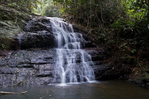
Takah Selow 1. This is the lowest tier out of three.
Takah Selow is a three tiered waterfall which is the nearest and easiest waterfall to reach, from Base Camp. It should take about 30 minutes to arrive at the lowest tier, a nice, photogenic cascade, perfect for photography. I suspect the name is derived from the English word “Slow”, which somehow became “Selow”.
Takah Pandan
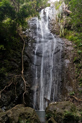
Takah Pandan is perhaps the prettiest waterfall in the immediate, accessible Selai area.
Takah Pandan is a beautiful, vertical cascade that is about an hour’s trek from Base Camp. The waterfall is probably 40 or 50 meters in height. The trail to it involves scrambling up steep riverbanks and can prove strenuous, especially if one is not fit. Nonetheless, the waterfalls are a fitting reward for all that exertion. Towards its left is another smaller “sister” waterfall, which does not resemble it in appearance, and appears to be from a differing source. This waterfall is probably Takah Selow 3 (the top tier).
Takah Berangin

Takah Berangin is a nice waterfall to have a splash, especially after the long trek to reach it. There is a constant spray and mist generated by its powerful cascade. Nonetheless, it is still safe to be approached.
Takah Berangin is a powerful cascade that is about 2-3 hours trek from Lubuk Tapah. In order to reach it, you continue a further 1-1.5 hours from Takah Pandan through beautiful lowland and hill dipterocarp forest. This is one of the few trails that do not follow alongside the rivers. The powerful water flow can be heard even from some way off. However, the pool is safe for swimming and it’s a nice spot to cool off after a long trek. As with other falls in the park, the pool teems with fishes.
Contact details for Johor National Parks Corporation
http://www.johorparks.blogspot.com/p/contact-us.html

May 22, 2017 at 2:57 pm
Very informative, a full story of endau rompin. i work in endau rompin selai and there are so much to learn, i believed we met during your visit but i cant remember. thank you mr jungle boy for visiting endau rompin selai, really hope that you can revisit our park and we the park staff can ask you a lot of questions about our rainforest especially endau rompin.
May 22, 2017 at 2:58 pm
Owh, can i share your endau rompin selai journal to our official fb Johorparks endau roin selai?
May 23, 2017 at 10:05 am
@ Anas
Thanks for your comments! Yes, you can share my blog to your Johorparks page. I think I remember someone called Anas, during my trip 😉
June 25, 2017 at 10:33 am
Hello,superb informative! I just wonder if its possible to visit as two backapckers,meaning we dont have large group to hire guide and probably (guessing) not the budget to hire private one….any tips on this matter? How to explore OR where to find find more info? Your article realy made me need-to-go there
June 25, 2017 at 12:22 pm
@ Jan
Thanks for your comment. You do need a guide if you wish to explore Endau Rompin in greater depth, as I believe this is the policy of the Johor National Park Corporation (who manages the area). And there is actually quite a good reason – The deeper you go in, the paths will be more obscure, and also the landscape is quite grueling, with a lot of ups and downs, and scrambling on pretty steep riverbanks 🙂 But the beauty of Endau Rompin is unique and its waterfalls are just worth it. I don’t think the guide rate per day is too expensive, but you can inquire from the Johor State Park Corporation site link that I gave at the bottom of my article.